


lac du bouchet

raab
User
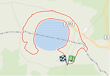

Length
6.4 km

Max alt
1299 m

Uphill gradient
161 m
Km-Effort
8.5 km

Min alt
1208 m

Downhill gradient
162 m
Boucle
Yes
Creation date :
2020-08-28 11:16:32.37
Updated on :
2020-08-28 11:21:28.914
--
Difficulty : Very easy

FREE GPS app for hiking
 SityTrail
IGN / Geographical institutes
SityTrail Plus
The world is yours!
About
Trail On foot of 6.4 km to be discovered at Auvergne-Rhône-Alpes, Haute-Loire, Le Bouchet-Saint-Nicolas. This trail is proposed by raab.
Positioning
Country:
France
Region :
Auvergne-Rhône-Alpes
Department/Province :
Haute-Loire
Municipality :
Le Bouchet-Saint-Nicolas
Location:
Unknown
Start:(Dec)
Start:(UTM)
562751 ; 4972471 (31T) N.
Comments